
GIS Production Services
Professional GIS spatial data analysis and processing. Remote engineers embedded in your pipeline, delivering production-ready outputs in any format you require.
Estimate within 48 hours
1-month risk-free trial
Onboarding in 1–2 weeks
Common Pain Points
Engineering teams handling large spatial datasets face the same production bottlenecks. Our geospatial data analysis service is built to resolve them systematically.
Inconsistent GIS Datasets
Conflicting projections and schema mismatches stall downstream processing and delay delivery.
Overloaded Internal Teams
Your in-house GIS staff cannot absorb peak project volumes without quality tradeoffs.
CAD–GIS Data Mismatch
Geometry and attribute discrepancies between AutoCAD deliverables and GIS layers create rework loops.
Coordinate System Conflicts
Mixed CRS references across project phases introduce positional errors that compound over time.
Slow Data Processing
Manual workflows for point cloud classification, topology repair, and feature extraction take too long.
Poor Data Quality
Missing attributes, invalid geometries, and unverified sources degrade final deliverable accuracy.
What We Do
In a modern engineering and commercial context, geospatial data analysis is the comprehensive process of gathering, manipulating, and interpreting geographic and spatial data using advanced computational models to drive accurate engineering decisions.
Beyond Basic Map-Making
We turn raw field data into production-ready digital twins, databases, and topographic plans that comply with industry standards.
On-Demand GIS Production Capacity
Scale your GIS output without expanding headcount or adding tooling licences.
Full Lifecycle of Spatial Data Processing
From data ingestion and topology validation through LiDAR classification to final compliance package delivery.
Office-Based Processing from Your Data
You supply the source data and we process, analyze, and deliver engineering-ready outputs. No field work.
Services Included
We deliver high-throughput geospatial analysis solutions for infrastructure, municipal development, and surveying projects worldwide.
Seamless integration of disparate vector and raster layers, precise coordinate transformations, topology validation, and geometric error correction across complex multi-source projects.
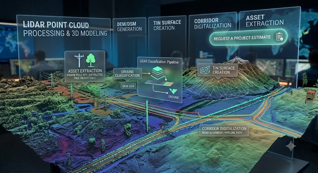
Generation of digital elevation models (DEM/DSM), TIN surface creation, corridor digitalization, and asset extraction from raw LiDAR point clouds using industry-leading classification pipelines.
Drafting of comprehensive topographic plans and preparation of region-specific compliance packages and architectural planning authorities.
Building sophisticated spatial queries, conducting network analysis, and generating executive-level reports for investors, municipal authorities, and engineering project stakeholders.
Technology Stack
We customize our technology stack to fit the exact technical specifications of your project, using the industry's leading geospatial analysis tools across every processing domain.
GIS & Analytics
Multi-layer spatial analysis, database schema management, advanced querying and spatial joins.
ArcGIS Pro
QGIS
CAD & Engineering
Corridor digitalization, topographic drafting, 3D terrain modeling and alignment design.
AutoCAD Civil 3D
Point Cloud & 3D
LiDAR classification, feature extraction, 3D mesh texturing and visualization for engineering review.
Autodesk ReCap
TerraExplorer

Automation Advantage
We don't rely solely on off-the-shelf software. To deliver services up to twice as fast as traditional geospatial data analysis companies, we utilize proprietary automation tooling that eliminates repetitive manual tasks from the production pipeline.
By automatically generating topographic maps directly from input survey codes, we pass the speed and cost benefits directly to you.
Custom GIS Plugins
Purpose-built extensions for ArcGIS Pro and QGIS that automate repetitive spatial processing tasks across large dataset batches.
J.O.T Complex Plugin
Handles complex topographic object classification and symbology generation directly from survey code inputs.
J.O.T AutoCAD AI Plugin
AI-assisted drafting layer that automatically generates compliant topographic maps from field data codes — no manual layer assignment required.
Delivery Model
Among geospatial data analysis companies, we stand apart with a delivery model that places a fully managed, dedicated unit of spatial engineers directly inside your pipeline.
What You Receive
Every output is verified, documented, and formatted to slot directly into your engineering workflow, without rework.
Utilities & Telecom
Network mapping, utility GIS data services, asset management and corridor analysis.
Engineering & AEC
Topographic mapping, 3D terrain modeling, and compliance package preparation.
Infrastructure
Road and rail corridor digitalization, drainage analysis, and cadastral integration.
Transportation
Logistics network analysis, route optimization data, and transport corridor mapping.
What You Receive
Every output is verified, documented, and formatted to slot directly into your engineering workflow — without rework.
Topographic Plans
Fully drafted, regulation-compliant topographic maps in CAD and GIS formats.Fully drafted, regulation-compliant topographic maps in CAD and GIS formats.
Digital Elevation Models (DEM/DSM)
High-accuracy terrain surfaces derived from LiDAR and survey data.
Classified Point Clouds
Processed and segmented LiDAR datasets ready for engineering review and extraction.
Spatial Databases
Standardized GIS databases with validated schemas, topology, and attribute completeness.
Network Analysis Reports
Spatial query outputs and executive-level reports for stakeholder distribution.
Compliance Packages
Region-specific deliverable packages for regulatory submission.
3D Terrain Models & TIN Surfaces
Structured 3D datasets for Civil 3D integration and infrastructure design.
FAQ
Get Started
Our managed teams cover a wide range of adjacent geospatial disciplines to support the complete lifecycle of your engineering projects.
Remote embedded GIS engineering services for global infrastructure operators. Office-based post-processing, deployed in 1–2 weeks.
GET IN TOUCH
We’ll respond within 48 hours