
GIS Data Services
GIS database setup, spatial data management, schema standardization, and geospatial data processing for engineering and infrastructure teams. Our remote specialists manage the data layer, so your production team doesn’t have to.
Estimate within 48 hours
1-month risk-free trial
Onboarding in 1–2 weeks

Common Pain Points
GIS database admins and data teams managing spatial data across multiple projects and platforms face the same recurring problems. Poor spatial data management costs time, causes analysis errors, and creates compliance risk. Our services resolve these at the database level. Not symptom by symptom.
Inconsistent Schema Across Projects
Different projects use different layer naming, attribute field names, and data types. There is no single spatial data management plan and merging datasets for reporting or analysis requires hours of manual cleanup every time.
Data Quality Degradation Over Time
GIS databases accumulate errors as data is updated by multiple teams without a consistent QA process. Geometry invalidity, duplicate features, null attributes, and coordinate drift build up until the database is no longer reliable.
No Spatial Data Validation Process
Without automated spatial data validation tools and rules, errors are only discovered when they cause a visible problem downstream, by which point data has already been used in analysis or submitted to clients.
AutoCAD and GIS Out of Sync
Engineering teams work in AutoCAD while GIS teams work in ArcGIS or QGIS. Without structured spatial data management in AutoCAD and a clear GIS sync process, the two environments drift apart and reconciliation becomes a project in itself.
Uncontrolled Database Growth
Spatial databases accumulate redundant layers, superseded versions, and orphaned features. Without active GIS database management, storage bloats and query performance degrades.
No Capacity for Ongoing Maintenance
GIS data maintenance services require consistent specialist attention, not bursts of effort. Teams without dedicated capacity let maintenance slide until a database audit reveals months of accumulated problems.
What We Do
Spatial data management covers the full lifecycle of geospatial data within an organisation or project, from database design and schema standardisation to processing, quality assurance, validation, and ongoing maintenance. It keeps GIS data accurate, consistent, and usable across teams and platforms.
The Infrastructure Behind Reliable GIS Output
Every GIS deliverable is only as accurate as the data behind it. Spatial data management ensures source data is valid, correctly projected, complete, and consistent before entering production. Without it, errors are harder to trace, deliverables require rework, and databases become difficult to maintain.
Structure, Schema, and Long-Term Usability
Production-level GIS database management means designing scalable geodatabases with consistent field names, data types, domains, and relationships across projects. Our services cover feature datasets, topology rules, attribute domains, versioning, and archiving. We work with Esri File Geodatabase, GeoPackage, PostGIS, SpatiaLite, and Oracle Spatial.
From Raw Input to Validated, Analysis-Ready Data
Geospatial data processing covers the steps between raw spatial data and analysis-ready output, including format normalization, coordinate transformation, geometry repair, topology validation, and attribute standardization. Our validation process applies configurable rules for topology, domains, completeness, and CRS, with a validation report for every release.
Consistent Quality Over Time, Not Just at Launch
A spatial data management plan is only effective when properly maintained. Our GIS data maintenance services include validation, schema updates, layer versioning, data corrections, and database audits. Ongoing support is available on retainer or as needed, keeping your data accurate while your team focuses on using it.
Services Included
Six core services covering GIS database design, geospatial data processing, spatial data validation, maintenance, and AutoCAD-GIS integration. All for ongoing or project-specific engagements.
GIS database design from scratch, including feature datasets, schema definitions, attribute domains, topology rules, and CRS configuration. Available in Esri File Geodatabase, GeoPackage, PostGIS, or SpatiaLite to suit your platform.
Configurable spatial data validation based on project-specific rules for topology, attribute completeness, domain compliance, CRS, and geometry. Validation can run automatically on schedule or on demand before data release.
End-to-end data processing including format normalization, coordinate transformation, geometry repair, feature classification, attribute population, and duplicate detection. Python (ArcPy, GDAL/OGR) and FME workflows support automated processing of large datasets.
Ongoing GIS data maintenance including validation, schema updates, attribute corrections, layer versioning, and database audits. Available on a monthly retainer or as-needed basis.
Structured spatial data management for AutoCAD environments, including layer naming, block attribute schemas, CRS-aware drawing organization, and AutoCAD-to-GIS workflows. AutoCAD and Civil 3D data can be aligned with your GIS schema.
Targeted correction of existing GIS databases, including geometry repairs, topology fixes, attribute standardization, missing data, duplicate removal, and CRS realignment. Every project includes a before-and-after QA report.
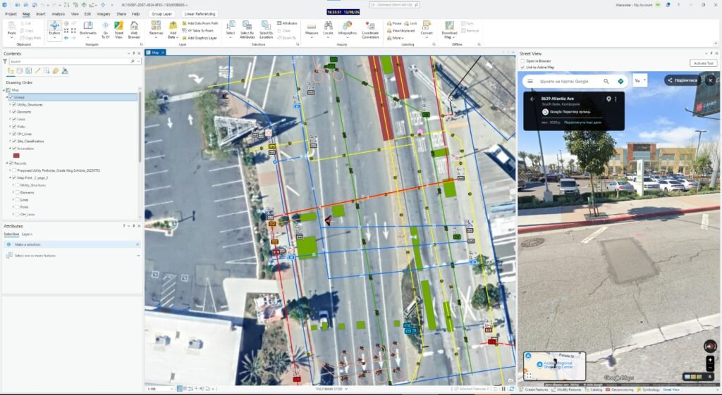
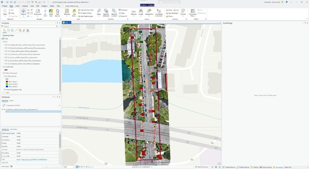
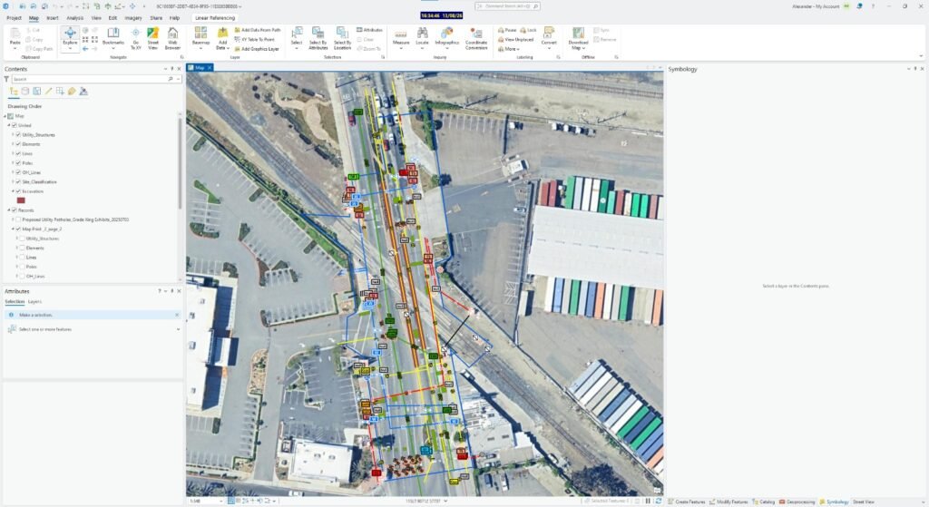
Location plans created from panoramic imagery, drawings, and field survey data. We digitize utility markings, underground infrastructure, and network layouts to your standards. The result is a structured spatial plan that helps excavation and repair teams locate existing utilities and avoid damage.
Technology Stack
Our spatial data management specialists are fluent in the full range of GIS database platforms, validation tools, and geospatial data processing environments. Integrate into whichever stack your team already uses.
GIS Platforms
Spatial data management in GIS, database design, topology QA, and geospatial data processing.
ArcGIS Pro
QGIS
Spatial Databases
GIS and database management include, schema design, versioning, query optimisation, and long-term data storage.
PostGIS
GeoPackage
Data Processing
Batch geospatial data processing, spatial data validation tools, format conversion, and automated QA pipelines.
Python
QGIS Processing
PROJECT EXAMPLES
Real deliverables from completed projects
GIS database architecture, data QA, and schema standardization, built entirely from data our clients provided.
Delivery Model
Dedicated spatial data management capacity without the overhead of a full-time GIS database administrator, or the inconsistency of leaving data quality to whoever is available.
Industries Served
Our geospatial data processing and management services are deployed across the full range of industries where spatial data accuracy is operationally critical.
Utilities & Telecom
Network asset GIS database management, utility layer schema standardization, and geospatial data processing for field data integration.
Engineering & AEC
Project geodatabase setup, CAD-GIS schema alignment, and spatial data validation for multi-team infrastructure projects.
Municipal & Urban Planning
Spatial data management plans for planning authorities, covering cadastral databases, land use layers and zoning schemas.
Infrastructure & Transport
Road and rail network GIS database management, as-built data integration, and geospatial data processing for corridor monitoring.
What You Receive
Every engagement delivers not just corrected data but the documentation to maintain it — so your team understands what was done and how to keep it consistent going forward.
Database Audit Report
Structured findings from the initial data review, covering schema inconsistencies, geometry errors, attribute gaps, CRS issues, and redundant layers. Includes prioritised recommendations and effort estimates.
Spatial Data Management Plan
Documented schema standards, naming conventions, validation rules, update procedures, and QA acceptance criteria. This provides your team with clear guidelines for maintaining data quality over time.
QA-Verified Geodatabase
Corrected spatial database delivered in your required platform format, including File GDB, GeoPackage, or PostGIS schema export. Data is topology-valid, attribute-complete, and CRS-confirmed.
Spatial Data Validation Reports
Per-release validation reports covering topology rules, attribute completeness, domain conformance, CRS verification, and feature counts. Each report includes pass/fail status and a correction log.
GIS Data Correction Log
A complete record of geometry repairs, attribute corrections, duplicate removals, and schema changes. Each change is traceable to the source error and the rule that triggered it.
AutoCAD–GIS Schema Documentation
Layer naming standards, block attribute mapping, CRS configuration, and sync pipeline documentation for teams managing spatial data management in AutoCAD alongside a GIS platform.
Ongoing Maintenance Reports
Monthly or quarterly maintenance summaries: validation results, corrections applied, schema changes, database size and performance metrics, and recommendations for the next period.
FAQ
Get Started
Start with a database audit and see exactly what your spatial data looks like — then decide whether you need a one-off remediation or an ongoing spatial data management arrangement. Our specialists work in your platform, follow your standards, and deliver QA documentation with everything.

Remote embedded GIS engineering services for global infrastructure operators. Office-based post-processing, deployed in 1–2 weeks.
GET IN TOUCH
We’ll respond within 48 hours