
GIS Production Services
Custom geospatial mapping and digital mapping for infrastructure, construction, and land development projects. Remote GIS engineers embedded in your workflow, delivering production-ready GIS maps in any format and coordinate system you require.
Estimate within 48 hours
1-month risk-free trial
Onboarding in 1–2 weeks
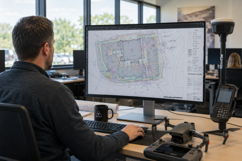
Common Pain Points
Engineering teams managing survey data and spatial deliverables across multiple projects face recurring production problems. Our GIS mapping services are built to resolve them at scale, with dedicated specialists who know exactly what engineering-grade geospatial mapping requires.
Inconsistent Source Data
Raw survey data arrives in mixed formats and projections. Reconciling it manually before mapping can consume days of billable engineering time.
No Capacity for Peak Volumes
Your in-house team can handle routine output, but when multiple projects land simultaneously, GIS map production stalls or quality drops.
Compliance Complexity
Different clients, regions, and authorities require different mapping standards. Tracking INSPIRE, and local cartographic specifications across projects creates constant overhead.
Slow Topographic Drafting
Producing accurate topographic maps from point cloud or survey data is time-intensive. Manual classification and symbology workflows don't scale.
CAD–GIS Layer Misalignment
Geometry and attribute discrepancies between your AutoCAD deliverables and GIS layers create rework loops that delay final handoff.
No In-House GIS Mapping Specialist
Firms that need periodic geospatial mapping output often can't justify a full-time hire, but project schedules can't wait for recruitment.
What We Do
GIS mapping services turn spatial source data into accurate digital, topographic, and cartographic maps. We work with LiDAR point clouds, aerial imagery, field surveys, and satellite data to create outputs ready for planning, permitting, infrastructure design, and regulatory submissions.
At GIS J.O.T, certified remote specialists work directly within your existing workflow, using your tools and following your delivery schedule.
More Than Digital Cartography
A GIS map for engineering requires precise metadata, topology rules, coordinate systems, and CAD-compatible layer structures. It must meet the requirements of the receiving authority, planning team, or contractor. Our engineers produce geospatial mapping to engineering-grade specifications, not general-purpose cartographic standards.
On-Demand GIS Production Capacity
For GIS managers, data engineers, and spatial analysts, managing complex datasets to strict engineering standards can quickly become resource-intensive. Professional geospatial data analysis services allow you to scale production without expanding permanent staff or tooling licenses.
Full Lifecycle of Spatial Data Processing
We cover the entire lifecycle, from initial data ingestion, topology validation, and coordinate transformation through LiDAR classification, 3D surface generation, and compliance package delivery. Our primary focus is on exceptional data quality and rapid, predictable turnaround.
Office-Based Processing from Your Data
We are an office-based GIS production team. We do not conduct field surveying, drone flights, or data capture. You supply the source data, LiDAR scans, satellite imagery, existing CAD files, or raw survey measurements, and we process, analyze, and deliver engineering-ready outputs.
Services Included
From topographic map creation from raw LiDAR to large-scale geospatial data mapping for infrastructure projects. Producing engineering-grade output in every format you require.
Elevation-accurate terrain plans at 1:250–1:5000 scale with TIN surfaces, contour lines, and spot heights, produced from LiDAR point cloud, total station, or drone survey data. Full CAD layer structure included.
Ongoing GIS map production from satellite, aerial, or field source data, fully attributed vector datasets output to Shapefile, GeoJSON, GeoPackage, KML, or DWG in your required coordinate reference system
Field survey data processed into regulation-compliant GIS survey maps. Includes boundary delineation, infrastructure positioning, utility network mapping, and geodetic coordinate alignment.
Styled cartographic map outputs and permit plan packages at 1:100–1:500 for planning authority submission. INSPIRE-compliant, or bespoke cartographic standards.
Compilation and attribution of geospatial datasets from multiple source layers into a unified, QA-verified spatial database with consistent projection, topology, and schema.
Spatial analysis outputs (land use, zoning, infrastructure density, flood risk, slope classification) delivered as engineered GIS layers and styled map compositions for planning documentation and reporting.
Technology Stack
Our engineers are fluent in the full stack of GIS mapping and cartographic production tools and adapt to any platform your workflow requires.
GIS Mapping & Analysis
Digital mapping, geospatial data mapping, layer analysis, cartographic styling and map output.
ArcGIS
QGIS
ArcMap
CAD & Survey Integration
Topographic map creation, GIS survey map drafting, permit plan production and CAD layer structuring.
AutoCAD Civil 3D
AutoCAD
Point Cloud Processing
LiDAR-to-map workflows, 3D feature extraction, terrain modeling and topographic map creation.
Autodesk ReCap
TerraExplorer
Photogrammetry
Drone imagery to orthophoto, elevation model, and point cloud pipelines for geospatial mapping.
Agisoft Metashape
Data Integration
Format conversion, CRS transformation, geospatial data mapping across mixed source datasets.
FME
Python
Remote Sensing
Satellite imagery classification, multi-spectral analysis for land use and thematic GIS maps.
ERDAS IMAGINE
ENVI

Automation Advantage
Topographic map creation from survey data often requires extensive manual classification, layer assignment, and symbology. Our automation tools reduce this work by generating topographic maps directly from survey codes in Civil 3D.
For large or repetitive geospatial projects, we build custom Python and FME workflows to batch-process, reproject, validate, and export spatial data with minimal manual input.
J.O.T Complex Plugin
Purpose-built for Civil 3D and AutoCAD; Automates survey data processing, topographic map generation, and bulk attribute management. Eliminates manual classification from raw point to drafted symbol.
JOT AutoCAD AI Plugin
Write a plain-language prompt, receive executable AutoCAD code instantly. Attach a screenshot of your drawing to refine the output. No scripting knowledge required. Works in multiple languages.
Custom GIS Automation Pipelines
Python (ArcPy, GDAL/OGR) and FME workflows for automated geospatial data processing, including reprojection, schema alignment, topology repair, and multi-format export.
PROJECT EXAMPLES
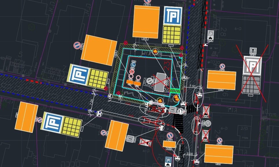
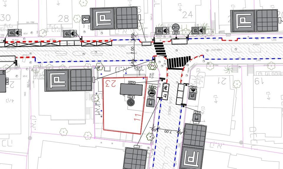
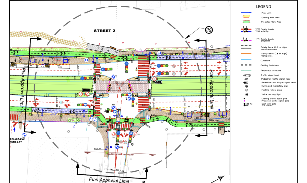
Selected outputs from completed GIS mapping engagements, spanning topographic mapping, CAD conversion, and 3D terrain reconstruction. All produced entirely from client-supplied survey data.
Delivery Model
Among geospatial data analysis companies, we stand apart with a delivery model that places a fully managed, dedicated unit of spatial engineers directly inside your pipeline.
Industries Served
Our GIS mapping services have been delivered across the full spectrum of infrastructure, planning, and land development sectors worldwide.
Utilities & Telecom
Network mapping, underground utility surveys, asset GIS maps and corridor digitalization.
Engineering & AEC
Topographic mapping, as-built GIS survey maps, permit plan packages and regulatory compliance output.
Infrastructure
Road and rail corridor mapping, interchange digitalization, surface models and alignment data.
Oil, Gas & Energy
Pipeline corridor GIS maps, facility asset mapping, environmental buffer spatial analysis.
Environmental
Habitat and land use mapping, flood risk and slope mapping, environmental impact GIS layers.
Municipal
Urban block digitalization, zoning mapping, cadastral and land use GIS deliverables.
Agriculture
Field boundary mapping, irrigation and drainage GIS, crop classification from satellite imagery.
Real Estate & Development
Site survey maps, boundary and zoning plans, due-diligence geospatial mapping packages.
What You Receive
Every GIS mapping deliverable is verified, documented, and formatted to slot directly into your engineering or permitting workflow, without reworks.
Topographic Plans
Regulation-compliant topographic maps in CAD and GIS formats, with contour lines, TIN surface, spot heights, and full layer structure.
GIS Survey Maps
Geodetically referenced site survey plans including boundary definition, utility networks, and infrastructure positioning.
Digital Map Files
Vector GIS maps in Shapefile, GeoJSON, GeoPackage, KML, or DWG projected to your required coordinate reference system.
Digital Elevation Models (DEM/DSM)
High-accuracy terrain surfaces from LiDAR or photogrammetric data, in GeoTIFF or CAD-compatible surface format.
Permit Plan Packages
Cartographic packages at 1:100–1:500 for regulatory submission, including north arrow, legend, scale bar, and coordinate grid.
Thematic & Analytical GIS Maps
Styled, attributed layers for environmental, zoning, and infrastructure analysis deliverables.
Compliance Packages
Region-specific outputs (INSPIRE, local authority standards) with all required metadata and documentation.
FAQ
Get Started
Stop letting geospatial mapping production bottlenecks delay your infrastructure project timelines. Our engineering specialists deliver GIS mapping services for clients across Europe, the UK, North America, and the Middle East.

Remote embedded GIS engineering services for global infrastructure operators. Office-based post-processing, deployed in 1–2 weeks.
GET IN TOUCH
We’ll respond within 48 hours